Today we are going to explore one of the themes that we like to talk the most, as explorers and nature lovers, walking is part of our genetics, as we believe it is the simplest and most true way to get to know a place and the nature that surrounds it.
We will not talk about any hike, but about some of the wonderful hikes possible to take in the Peneda-Gerês National Park.
Being traveled only on its roads is already wonderful … imagine now walking it on its magical trails through the forest and through its higher altitude regions, where normally only the locals and the most adventurous go.
In our opinion, the best time of year to walk in the park is spring and the mild beginnings of summer, first because around you and in all directions it will be an explosion of new life brought by the time of year in question, then because the trails dry up from the harsh winter rains and become more accessible and less dangerous, which makes walking much safer, thus making the most of your surroundings.
In the park there are trails for all tastes, all ages and physical forms, bigger and smaller in terms of distance, trails that last a whole day round trip and trails that last 3 to 4 hours.
In terms of signage, there is a large set of trails properly signposted and according to international standards, however, there are also less careful trails and with lack of signage.
For these ones we ask for prudence and do it just if you have the experience and knowledge of the terrain, or if you are properly accompanied, let the adventurous spirit invade you, but without putting you at risk.
Continuing with the care to be taken, we reinforce that it is necessary to wear proper clothes for walking, as well as protection for the head in the hottest days, comfortable shoes and with good grip in order to prevent falls and injuries.
No less important is water, although the park has a very comprehensive network of sources, but it is always necessary to take a good amount of water, taking into account the distance to be covered and the atmospheric conditions that are felt and do not forget the snack, which as you should know, walking, makes you hungry!
So, looking to help you when the time comes to choose, we leave you our selection of trails, so you can satisfy your need to walk!
“PEDRA BELA – ARADO” TRAIL
Location: Peneda – Gerês National Park
Starting Point: “Pedra Bela” Viewpoint
Extension: Aprox. 12 km
Duration: +- 4h
Difficulty Level: Moderado
Minimum / Maximum Height: 705m – 1048m
Trail Type: Natural and Landscape Trail – Partially Signposted and Circular
“Pedra Bela” Viewpoint
Nothing better to start a trail in this incredible National Park than the view of “Pedra Bela”, considered by many to be the best view of the park, certainly that will give you that extra strength needed for the execution of this beautiful trail.
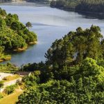
If the weather allow from here you will have a very comprehensive view, it will give you a beautiful perspective on “Albufeira da Caniçada” and “Portela do Homem”, where the nearest border is located.


“Pedra Bela” Forest House
Just off “Pedra Bela” you will come across a building entirely built with large granite blocks and with a tower reminiscent of a lighthouse.
This was where the park guards used to stay overnight, serving as the base from which they left to make their lookouts in the park , nowadays with no apparent use, is a reminder of other times.
“Curral da Carvalha das Éguas”
Built next to an imposing oak, we find this simple but very useful shelter, which for years on end has been used by the shepherds of the region during the “Vezeiras”.
Of humble construction, using a granite rock as one of the walls, it has a source of drinking water that you can use to get supplies, you must use the gate to enter and you must close it at the exit, remember to preserve.


“Curral da Lomba do Vidoeiro”
Here you will find the second shelter on this trail, this a very small one, which makes us wonder how difficult it will be to stay overnight inside.
Although small, it has some very curious elements, a cross over the door, most likely as a symbol of divine protection, a table made with a granite slab and even a type of cabinet made of the same rock.
If you think you are lost, just look and see the countless “mariolas”, small piles of rocks stacked on top of each other, which served as a guide for the shepherds, so trust that you are on the right path.
Perfect place to rest a little and enjoy what surrounds us.
Shelter of “Vale da Teixeira”
After resting and a few kilometers further on, we will meet “Vale da Teixeira”, entrenched in the middle of two large granitic massifs, one of the things that immediately stands out is a small house in the middle of the valley, called “Abrigo da Teixeira”.
Like the previous two, it serves as a shelter for the shepherds, however the conditions of the this one are frankly better, as it is much larger than the others even having a roof made of tile, something that the others do not have, however it remains a humble construction that have only the basic conditions of subsistence.


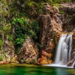
Waterfall of “Arado”
Since our direction will be descending, we will have a privileged view from the top of the waterfall, where we can sit for a while and rest our legs from the long walk.
Then it will be the descent, which should be done on the left side of the waterfall where in the middle of the descending, a balcony appears from where you can contemplate the waterfall in a frontal direction, a sight not to be missed.
Viewpoint of “Rocas”
With the “Arado” waterfall behind, it is time for the last attraction of this trail before we start the climb back to the starting point at “Pedra Bela”.
Where the dirt road that brings us from “Arado” meets the main road, there will be a huge rock on your left, this is the last challenge, to climb up there.
We know your legs are already tired, but the view will certainly be rewarding, from the top you will have a 360º view over the surrounding region, the last incentive to end this trip.

TRAIL PR14 TBR – “SOBREIRAL DA ERMIDA DO GERÊS” TRAIL
Location: Village of “Ermida”, “Vilar da Veiga” – Peneda – Gerês National Park
Starting Point: “Ermida” Tourist Office
Extension: Aprox. 15 km
Duration: +- 5 h
Difficulty Level: Moderated
Minimum / Maximum Height: 206m – 800m
Maximum slope: 36%
Trail Type: Natural and Landscape Trail – Signposted and Circular

Village of “Ermida” and Viewpoint
This trail starts in the beautiful mountain village of “Ermida”, located 550 meters above sea level, it is a village with an agro-pastoral vocation.
From here you will be able to contemplate the granite massifs of “Gerês”, its countless valleys and slopes, the rural architecture and the historical elements of the village, all in a panoply that most resembles a painting, because how beautiful it is.
Bridge and Waterfall of “Arado”
After some time of walking, it is time to glimpse the beautiful waterfall of “Arado”.
This waterfall represents a well-marked landmark in the landscape, characterized by its high waterfall that at the bottom allows the existence of a beautiful lagoon with crystal clear waters.
The waterfall is supplied by the “Arado” River, which in turn derives from the “Teixeira” and “Arieiro” River.
Not far from the waterfall and along this trail we find the “Arado” bridge, which built in 1936 allows us to cross the river and climb up to the mountain, so that we can contemplate the verdant wealth on the banks of the “Arado”.


“Curral da Malhadoura”
Another of the attractions of this trail are the corrals where the shepherds protect themselves and their animals when carrying out the typical pastoral tradition of “Vezeira”.
Which consists of driving cattle to the pastures in the high mountains for days or even weeks, hence the central importance of these sites, which normally consist of a pasture site, a source with drinking water and a shelter, for the shepherds’ overnight stay.
During the trail, “Curral da Malhadoura”, the most significant, “Curral de Portos” and “Curral de Destes”, should be noted.

Fauna e Flora
Since the trail passes through different altitudes and sites with different geological components, we will pass through agricultural, forest, riverside and even bush areas.
In each of these areas the landscape changes in flora and fauna. In the areas of an agricultural nature, the presence of fruit trees and the cultivation of vegetables and other essential products for the daily life of the village stand out.
In the forest areas we highlight the existence of medium / large trees such as oak, chestnut, birch, arbutus and in some parts but less abundant holly. However, not everything is big trees, close to the ground we have white heather, yellow-colored broom and gorse.
In the riverside areas of the “Arado” River, there are species of special care that are at risk and are of botanical interest, such as the “orvalhinha” and “pinguícola”.
With regard to fauna, near the village of “Ermida” we will have the presence of domestic cattle, such as the goats and cows that abound in the region and are essential to their livelihood, in the most isolated areas of the route as the corrals the habitat is quite favorable to the existence of the wild horse “Garrano”, the roe deer, the wolf that will certainly be very difficult to spot and other species such as squirrels and foxes.
A trail that certainly will not leave you indifferent, as it is a mixture of culture, history and nature, all on the same route.
TRAIL PATHS OF THE BREAD, PATHS OF FAITH
Location: “Vila do Soajo” – Peneda – Gerês National Park
Starting Point: “Laje” in “Vila do Soajo”
Extension: Aprox. 5 km
Duration: +- 3 h
Difficulty Level: Moderated
Maximum Height: 506 m
Trail Type: Cultural and Landscape Trail – Signposted and Circular
This trail is of enormous symbolism for the people of “Vila do Soajo”, where it begins and ends.
It fundamentally represents the connectivity between two very important aspects, as the name indicates, on the one hand the whole cycle of bread that can be portrayed by these paths where on the sides run waterways that supply the existing corn fields, which for several hundreds of years have provided the mills located on this same route with corn, which, moved by the force of the water, in turn supply the flour to the village, where hands taught by the time knead the bread that feeds the people.
On the other hand, faith has always been very characteristic of this path, had it not been for the many believers in this region, alone or following pilgrimages that also passed through here with the same destiny to worship the “Senhor da Paz”, “Senhora da Peneda” or “S. Bento do Canto” and even walkers bound for “Santiago de Compostela” in Spain.
From the faithful, people from the fields, pack animals, herds of cattle and herds of goats, a little bit of everything has happened on this centenary trail. Don’t wait to be next.

“Calçada de Pena Curveira”
As it is a sidewalk, this will not only be one of the points where we will walk, but also one that we will have to contemplate, the most diverse people of the most diverse generations have passed through here for centuries.
Made of large granite blocks stuck in the ground, although old, it remains in a very good state of preservation, due to its maintenance by the people of the region.
We literally walk through the stories of those who have passed through here and if we think about it we realize how fantastic it is.
Watermills of “Cruz”
The sidewalk leads to the emblematic mills of the cross. At first glance they may look like simple watermills, but their simplicity has already taken hundreds of years placed there.
Static on the banks of the waterways that run there and provides them with the necessary energy for their vital function, that of grinding the cereals that since history prays, they feed the people of the region.


“Branda do Murço”
If you are not familiar with the term “Branda”, we will explain. “Branda” is a population center with seasonal characteristics, as a rule these are located on the plateaus of the mountain.
Where in spring and summer the fertile land is more likely to be cultivated and fed to livestock, its appearance is due to to the fact that it is impracticable to take and bring animals daily or every other day to the plateaus.
For that reason temporary dwellings were built, the “brandas” from which the name derives from the word “Varanda” or balcony, as they are located in high and sunny areas , which end up having a similar purpose to balconies, the use of the sun.
“Ínsuas”
Almost at the end of this trail we find what we call “Insuas”, examples of what were once “Brandas” that with time and lack of maintenance have fallen into disuse.
As the stone lasts for thousands of years, they stayed and continue to prove their influence on the people of the region and their way of life.
And so we finish one more of the beautiful trails in the park where we started in “Vila do Soajo”.

TRAIL “CASTREJO”
Location: “Castro Laboreiro” – Peneda – Gerês National Park
Starting Point: Crossroad “Castro Laboreiro”
Extension: Aprox. 17 km
Duration: +- 7 h
Difficulty Level: Moderated
Maximum Height: 1124 m
Trail Type: Cultural and Landscape Trail – Signposted and Circular

“Inverneiras” of the trail: “Barreiro”, “Assureira”, “Curveira”, “Cainheiras”, “Varziela”
This trail is made counterclockwise. More than a trail of unique beauty, with impressive landscapes and centuries-old paths, it is a trail that teaches us a lot about the experiences of those who live and depend on these lands.
Nowadays there is a lot of talk about “sustainability”, it is a theme of the moment, mainly related to tourism and agriculture and to the amazement of many, sustainability has been practiced in these lands for hundreds of years, here the people learned that forcing nature is not a solution and with that, they decided long ago to accompany it at the pace that it imposes on them.
As such, solutions were necessary to achieve an almost perfect balance between man and nature. In this way they decided to live according to the weather conditions, creating what we call “Inverneiras” and “Brandas”, seasonal population centers, which allow them to move with their animals, making the most of what each season of the year provides them.
In this way, with prior preparations and specific dates for this purpose, on December 15th, already with the cold making itself felt, the places moved to the “Inverneiras” low-lying areas protected from the cold, where they remained throughout the winter , until spring came, on 15 March they left their “Inverneiras” and returned to “Brandas”, going up to the high areas of the plateau where they stayed for most of the year, these being more fertile and with better pastures for the animals.
However, the locals regularly went to “Inverneiras” to take care of the soil, thus making the most of the 2 seasonal centers, always returning at the end of the day to the respective “Brandas”.
In this route that passes mostly in the low areas you will have a first-hand view of how these centers were built and how they operate, due to being a tradition to fall into disuse most of these centers are deserted, however there is always the exception to As a rule, and in any of the 5 “Inverneiras” on the route, you will certainly find people in the labors of the land or taking care of their beloved animals.
Chapel of “S. Brás”, Watermill and Bridge of “Assureira”
When passing through “Inverneira da Assureira”, it is worth noting a small chapel that contains traces of construction “Manuelina”, Portuguese architectural style, which appeared in the early 19th century and is characterized as the “Late Gothic”, however due to the little remodeling already made, the chapel has become uncharacteristic.
Next to the chapel you will also find a mill for the grinding of corn of uncertain date, but placed somewhere in the modern age and the Bridge of “Assureira”, which of the 3 mentioned elements is the oldest dating from the low middle ages in which curiously the best preserved parts are the oldest ones, if we look closely the largest blocks are the Roman ones that are in perfect condition, the smallest also present are the most modern and least conserved.
Suggestion: Before or after crossing the bridge take a small detour to the river and take a look at the bottom of the board, for sure you will notice the difference!


Bridge of “Cava da Velha”
Due to its extensive hydrographic network, this region has needed numerous bridges since distant times, the “Cava da Velha” being one of the oldest, dating from the 1st century, was built by order of the Romans when building connections between the territories conquered in Galicia in Spain, and the territories in the north of Portugal.
The bridge does not have its original appearance, having been reformulated in the medieval age.
“Bico do Patelo”
Following the paths of this trail and just after crossing the “Inverneira da Curveira”, you will find the “Bico do Patelo”, a strange granitic formation in the shape of a beak, reminding us of the head of a bird of prey, located on top of a rocky massif, worthy of all the pictures you can take.


Bridge of “Cainheiras”
From “Bico do Patelo” to “Inverneira das Cainheiras”, the walk will take a few more kilometers through these green landscapes, crossing one or other stream and the “Corga das Lapas” river.
Arriving in “Inverneira”, you will have the Bridge of “Cainheiras” waiting for you, of great importance for the population as it is one of the connections to the “Brandas” used in the summer, which are located next to the plateau on the left bank of the “Laboreiro” River.
This bridge in turn is much more recent than the previous ones dating from the 18th century, with simple construction, but very effective.
Bridge of “Varziela”
From “Cainheiras” we will not go very far until the last “Inverneira” of the trail called “Varziela”, as can be seen from the abundance of them, their role was of unparalleled importance for the population and their sustainable way of life. Here we find another bridge that helps us to cross these ancient paths, the Bridge of “Varziela”.
Of the countless in the region, this is the one with the most evidence of having been built in the medieval period, due to the few interventions that were targeted, dating its construction somewhere between the 12th and 14th centuries, representing a precious link between Galicia and the Portuguese territories.


Old Bridge of “Castro Laboreiro”
Already tired but certainly with a sense of accomplishment and overcoming, we have one last stop to make on this trail, the Old Bridge of “Castro Laboreiro”.
There it was established in a medieval style and which, despite the uncertainties, is thought to have been built somewhere between the 15th and 16th centuries. It serves as access to the watermills that were established by the water lines, also providing an essential passage for those who went to the castle.
Crossing the bridge, we finally reach the end of this trail, back to the fantastic village of “Castro Laboreiro”, where you will certainly have time to recover your energy, with the gastronomic delights made there.
Viewpoint of the Castle of “Castro Laboreiro”
After so many treasures along the way, we leave a small suggestion that will make you leave the contours of the village.
The walk was long and nothing better than a more comprehensive look at the whole region, so we suggest that you go to the Castle of “Castro Laboreiro” fortification built there for the defense of the region and control of the border nearby, by now you will certainly have realized of its imposing existence.
Enter the “Porta do Sapo” and enjoy the wonderful view and when the view is well explored you can return to the village through “Porta do Sol”.